
| Date | 10/10/2022 |
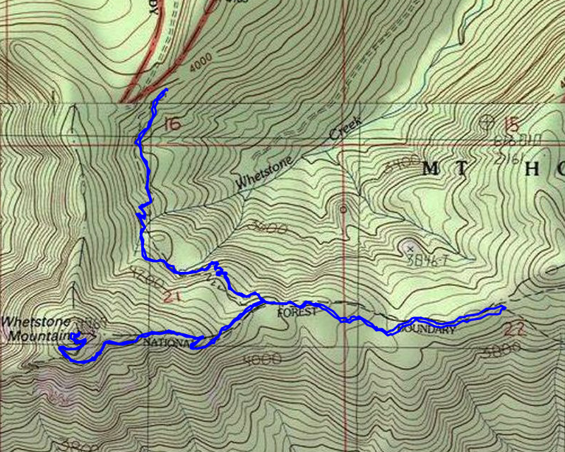
| Location / Trail | Whetstone Mountain Trail - 546 |
| Weather | Sunny |
| Hiking Buddies | Kirk, Ollie and Thor |
| Start / End | 11:00 AM – 5:00 PM |
| Distance / Elev | 6.25 miles 2300 ft elevation |
We headed out a little after 9 and had to stop twice along 224 for road work, but we still made pretty good time all the way out to the end of the 7020 road. As we were passing Bagby, we both saw and smelled smoke, and after our experience in 2020, right before the Riverside fire, we decided to stop to investigate – we didn’t see any cars around so it seemed kind of suspicious.
We parked near where we saw the smoke and walked into the woods – we came across a campsite down the hill which was occupied – they were just finishing up breakfast. We apologized for interrupting their morning and headed out. I’m glad we didn’t find anything unusual!
We made it out to the trailhead a little before 11:00:

We got suited up and headed out – the first part of the trail is pretty much as I remember it, although it did seem a bit brushier than I remember – probably because no one has been on the trail for 2 years.
We headed down the hill thru the old cut area and got into the old timber. It wasn’t too long before we got our first glimpse of the burn:

It didn’t last too long and we were back in unburned forest. Pretty soon we got to the rockslide area with the pond below it which didn’t burn:

But the area above the rockslide all burned – it just didn’t quite make it down the hill to the rockslide:

We kind of went back and forth between burned areas and unburned areas, but shortly before the junction that heads up to Whetstone Mountain, we got into what I called the “full burn”. From this point all the way to the top of Whetstone it was completely burned:

There was recent evidence of elk activity right on the trail – a pretty big elk print – I think the elk like the open areas:

We shortly got to the trail junction where we were surprised to see a brand new sign:

This was taken from roughly the same spot in 2015 – it looked VERY different:

We started up the ridge to the old lookout site. The going was somewhat difficult, especially when we came to areas like this with tons of stuff down in the middle of the tread:

As we continued up we had to really watch where we were going – there were several spots where we lost the trail. This is what it looked like below Whetstone – lots of fireweed and just weeds in general – tough to see the tread:

We did find the junction of the 3369 trail down to Opal Creek (Gold Creek trail) and right near the junction I kind of tripped on some old phone line:

We made our way up the trail, lopping here and there and throwing things off the trail trying to make it a little easier to follow. We finally made it to the top. A tiny bit survived on top on one side:

It was a pretty smoky day, so the views weren’t great. Here is looking south to Mt Jefferson in the smoke:

And another view looking down at the burn damage:

We stopped on top, gave the dogs some water and ate a late lunch. It was pretty warm up there – sunny, no shade and very little breeze.
After a bit we packed up and headed down. In some spots, coming down was harder than going up – the tread was hard to follow in places. Here is what some of the tread coming down looked like:

When we got down to the junction again, we decided to head east a bit. Originally I was kind of hoping we could go all the way over to the Bagby trail and head up to Silver King Lake, but given how difficult the trail was to navigate, we didn’t make very good time up to the top. So Silver King lake was out, but we decided to head east for a while. I kind of expected it to be burned pretty much the whole way, but it was intermittent burn and it seemed less intense than the burn around Whetstone. Many areas had a ground fire but the canopy was mostly intact.
We made it to the junction with the trail down to Battle Ax Creek where we found another new sign:

We stopped here for a bit and decided it was a good turn around point. We headed back west and then to the truck. The trip back was pretty uneventful, however I did snap a picture of the vibrant vine maple at the rockslide – I’m not sure how I missed it coming in:

We got back to the truck about 5:00 and headed out.
While I was saddened by all the damage from the fire, it was good to see that portions of it survived – it also opens up a lot of new views that you just couldn’t see before the fires which is kind of interesting. A beautiful fall day in the woods!