
| Date | 12/17/2022 |
| Location / Trail | Hillockburn Trail and Road 45 (closed to traffic) - 516 |
| Weather | Sunny and Cold |
| Hiking Buddies | Thor |
| Start / End | 10:00 AM – 2:10 PM |
| Distance / Elev | 8 miles 2000 ft elevation |
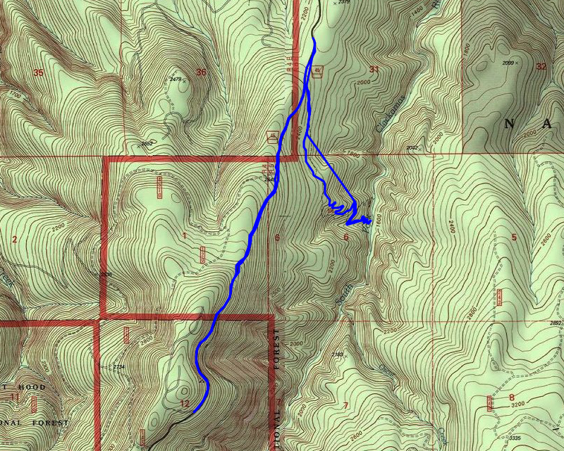
Today’s hike was intended to explore the damage done to the Hillockburn trail in the 2020 fires. Since we didn’t have to walk as far on road 45 to the trailhead as I thought (it is still closed due to “hazard tree remediation”), we ended up walking up road 45 a ways to see what we could see.
We got as far as we could get on road 45 – farther than I expected. I expected to have to park at the old yellow gate, but that was open – we got a bit farther up 45 up to a brand new green gate:

We walked around the gate and headed south on road 45 to the Hillockburn trailhead. It looks quite a bit different than it used to, and it appears the trailhead sign burned up – this is what it looks like now:

We proceeded down the beginning of trail, which is an old road:

Shortly we got off the old road and hit the “real” trail, which is somewhat overgrown due to the fires:

One thing that we crossed that I don’t ever recall prior to the fires was this small creek crossing – and someone has created a little crossing “bridge” over it:

As we proceeded down, the trail had many signs of post fire maintenance:

As we proceeded down the hill, the trail continued to get more overgrown and we encountered more downed logs. There was a HUGE uproot at a switchback that was hard to navigate:

A little farther down the trail, close to the river, I recognized this old cut log:

This is what it used to look like pre-fire:

As we got closer and closer to the river it got harder and harder. Thor at one point kind of of got lost coming downhill. I had to help him to figure out how to get down to the river. Down near the river is quite a mess:

Once we got down to the river, I saw this new sign – I’m sure it wasn’t here before the fire:

And then the requisite picture of the South Fork Clackamas river – looking north:

And here is a similar viewpoint what it looked like Pre-fire:

We stopped at the river and had a short lunch. After eating, we headed back up the hill. It wasn’t long before we were back at the 45 road. At this point it was a little after noon, and it was such a beautiful, peaceful day, I didn’t want it to end, so we started walking south up road 45. I was hoping at some point I might get a better look at the drainage and/or a view.
As we were walking up the road, I had been thinking about a memorial that I remember seeing along road 45. I was thinking it couldn’t possibly have survived the fires, but lo and behold, it did!

A little farther up the road I noticed some prints in the ice – I’m pretty sure these are kitty prints – they followed the road for quite a while:

As we progressed higher up the road, we were getting higher in elevation, but I also noticed the burn intensity was getting worse as well. As we got higher, the bark was blown off most of the trees, indicating a pretty hot burn:

I almost turned around, but decided to continue up and I’m glad I did because we did get some really good views, and I got to see some progress on the “hazard tree remediation” along road 45 (edit – after looking at this some more, this is not FS land – this is BLM land – so the FS has not started cutting along road 45, cutting has only occurred on BLM sections of road 45):

A little farther up, the cutting opened up this beautiful shot of Mt Hood and St Helens in the distance:

After seeing these beautiful views, I was tempted to turn around, but I was really curious how far they had gotten with the cutting. I went a little farther up 45, but couldn’t see the end of the cutting (I guess that is good?) and we ended up turning around about here:

I also took a photo of the South Fork drainage fire damage which was kind of interesting – there are still areas of green:

After turning around, the trip back to the truck was pretty uneventful – we made good time. Shortly before we got to the truck, we encountered a bicyclist heading south. He was the only person we saw all day long.
It was an interesting day – the quietest, most peaceful day I’ve ever had on this trail – normally there is lots of shooting nearby and/or lots of vehicle traffic on the road – or both. There was none of that today. It was also good to be able to get back into this area – if only by foot. Hopefully next year we will be able to drive in here and explore more burned areas.