
| Date | 12/26/2022 |
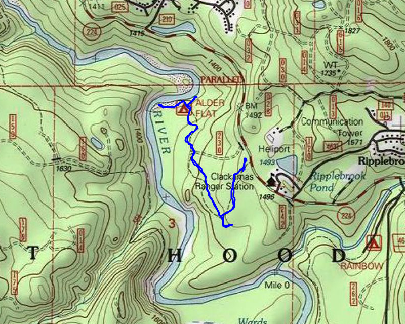
| Location / Trail | Alder Flat Trail - 574 |
| Weather | Overcast |
| Hiking Buddies | Thor |
| Start / End | 10:15 AM – 11:45 PM |
| Distance / Elev | 2.4 miles 600 ft elevation |
We left a little later than usual, since I figured we’d be back for a late lunch. We made it to the trailhead with no problems, although there were a few spots with snow/ice on 224 – nothing slippery but I was a bit surprised to see it after a couple days of warmer temperatures. It was almost 20 degrees colder at the trailhead than it was at home!
We started out – here is what the beginning of the Alder Flat trail looks like now – it has pretty extensive damage from the fires:

The good news is there are still green trees – many were killed but there are a fair number than were just scorched – they survived the fire. Here is one of the big logs that came down during the fire – it was sort of cut out post-fire – it wasn’t too far from the start of the trail:

A little farther down the trail a new log had come down – I cleaned up as much as I could with the loppers and hand saw I brought, so now it is just a climb over. As you go downhill down to the flat area above the river (that is very wet), you could see lots of tread work had been done. I’m guessing some of the trail slipped down the hill so they had to kind of rebuild portions of it.
As we got down to the flat area where there are several bridges, most of them were burned up – we had a bit of a challenge getting over some of the wet areas. Here is one burned out bridge:

As we were going along we saw lots of fresh deer and elk sign along the trail:

We soon came to another burned out bridge:

And soon we got to the campground along the river. We walked out onto the flood plain of the river and good a good view of it:

From there we walked upstream a bit – there is a big rock and kind of a rapids area – it was running pretty fast:

I also took a video of the river in this area:
We looked around a bit in this area and then headed back downstream. As we were walking I thought someone had been cutting up one of the trees along the flood plain but as we got closer, I realized it was a beaver who was doing it:

We saw a couple more trees with the same kind of cutting on them as we walked. We walked back to the campground (which was mostly unburned) and then headed a bit farther east on a “sort of” trail – it went up on a really interesting little spine, maybe 20 feet high. I thought it might have gone somewhere but it was just a weird little spine and then on the other side it came back down to the flat area around the river. We looked around a bit and then headed back up.
As we headed up I was looking for where an old road showed on the map intersecting the trail – I didn’t see one at all, so I think maybe it didn’t come that far. We crested the hill and took the turn by the big rock pinnacle (you couldn’t really see this before the fire unless you went off the trail):

It is at this point where there is/used to be a side trail that went over to the head of the swamp and the beaver dam. I had a hard time finding the trail at first, but eventually did – although it was pretty brushy. We followed it down to the swamp (it kind of appeared to be an old skid road or something – bigger than a trail), but it kind of disappeared into the brush. We went around and finally got a good view of the big swamp:

Right next to the head of the swamp I noticed this new bird box (I saw at least one more around the swamp too):

We got to the beaver dam and I’m assuming it must have burned since the swamp was quite a bit lower than it used to be:

This is what it looked like 2019 – you can see the water level is quite a bit higher and the dam was on the backside of that big log:

After looking at the beaver dam a bit we headed back out. On the way out I also ended up cutting out a few more small logs and brush to make passage a bit easier. We got back to the truck pretty quickly and headed out.
I drove up to the end of 224 just to see if anything there had changed (it had not), but the 4631 road gate was open. I was too chicken to drive up it, but it was curious that it was open. The gate up to Three Lynx was closed again and I also checked the gate on 4620, and it was closed as well, so my hopes that it might remain open have been dashed.
This was a quick day in the woods but it was interesting to see how this trail fared in the fires and nice to be out in the woods for a couple of hours.