
| Date | 1/1/2023 |
| Location / Trail | Fish Creek |
| Weather | Mostly Sunny |
| Hiking Buddies | Kirk, Ollie and Thor |
| Start / End | 9:55 AM – 4:15 PM |
| Distance / Elev | 10 miles 2400 ft elevation |
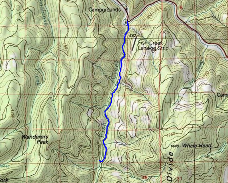
We headed out at the usual time and quickly got to the gate on Fish Creek road (at the bridge). There was one car parked there – we assumed they were hiking the Clackamas River trail. We headed up the road, which was kind of interesting – you see things you don’t normally see when you are driving by. A little ways up the road, one of the side creeks had a bit of a blowout – kind of like a much smaller version of what happened on 224 back in November:

Most of the road was in really good shape however:

A little farther up the road there was a neat little cascading waterfall off to the side of the road. I don’t recall seeing it before:

And a bit farther up was a small rockslide:

And remnants of a burned out guardrail:

It took longer than I thought it would, but we soon got to the beginning of the old road (trail):

We were surprised at how good this section of trail was – arguably better than it was before the fire. It was good until a little ways up the trail where we encountered this big cedar over the trail/road:

Upon further inspection this tree didn’t fall – someone cut it. That was a bit disappointing, but it was relatively easy to go up and around it. After that tree, it was pretty smooth sailing until we got to the Rimrock creek crossing, which has had its own blowouts it appears:

This is what the crossing looked like back in 2016 – you used to be able to pretty easily drive a quad thru here:

It took a bit of careful routing to get down to the creek and then across it, but the actual crossing wasn’t bad at all. After crossing, there is a side trail that goes back down to the old road 54 that goes along Fish Creek. This was built by quadders many years ago as a re-route around the lower Rimrock creek crossing (which has just continued to get worse and worse). Unfortunately, this portion of trail didn’t fare too well in the fires. The beginning is good, but soon disappears in a jumble of weeds and brush. We were able to follow it down well enough, but it felt like a cross country adventure rather than the well worn trail that was here before. It wasn’t long before we popped out on the old road 54 that follows Fish Creek:

And we found that someone had rigged up a cable and rope down the hill – we guessed this was to be able to get down to cross Rimrock creek:

We continued south on the old road and this portion was really, really good, with a few of this kind of thing sprinkled in here and there:

As we were walking, we were looking around at some of the new views that opened up after the fire. One thing that was really noticeable was the ridge along Fish Creek divide – it was BLACK:

I think once we can get back up to Fish Creek Mountain we are going to find that area pretty well torched – worse than any of the areas seen thus far.
A little farther down the trail, I took a photo of Fish Creek – this is at a bend in the river and it kind of a typical place to take a picture:

This is what this same area looked like back in 2018 (pre-fire):

And again way back in 2008 (one of the first times I came up the road) – The alders had not grown up nearly as much then:

As we continued down the road/trail there was intermittent logs down, however someone had come thru sometime earlier and cut out many of the logs, and cut notches in some of the larger logs:

As we progressed down the trail, I think we passed the point where the maintenance had been done and it got a bit worse – more grass/brush/blackberries and more blowdown. It wasn’t impassable however, just a bit slower. We got to the Second Creek crossing, which wasn’t too bad, but more challenging – Thor didn’t want to come over the log and so had to find his own way:

This is the same crossing back in 2011 – same log, but now there is a bunch of junk on the south end of it which made getting over a bit more challenging:

It wasn’t too far after the Second creek crossing where we hit the junction down to the first bridge. It is a bit more open in here than the last time I was in here pre-fire, but the road is still easily walked. There is an old campsite near the bridge:

This had a few trees still alive above it, however it is MUCH brighter in there than it used to be. Pre-fire that was a pretty dark campsite because of the huge trees covering it.
We made it to the first bridge:

and decided this would be our turnaround point. We stopped and had lunch and enjoyed the sunshine. Here is a view from the bridge looking north:

And a view looking south:

I also took a video of Fish Creek looking south – it was running pretty high and fast:
We ate lunch and looked around a bit – the dogs were playing. We decided not to go any farther because we weren’t sure how the Third Creek crossing would be and we were kind of running out of time. Days are short in January. I was honestly getting a bit tired as well, since we helped Zack work on his rental the prior day.
After eating lunch, we turned around and before we started heading north, we looked at the old campsite a bit closer. Kirk saw this rock, which from a distance looked like it was covered in barnacles but on closer inspection it was covered in ladybugs!:

That was certainly an interesting sight – something I’ve never seen before. We continued north and along the way we did some lopping and cutting of small trees/branches to help passage a bit. This trail could use more chainsaw work to clear some logs for sure, but we were very happy that someone had been thru before us to do some clearing.
As we were heading north, we heard some screeches, and looked up and we saw some Bald Eagles in trees high above the creek. I took this blurry picture of one of them:

That was pretty cool to see, even though it was high in the trees and hard to see. On the way back, I decided to take a picture of the First Creek crossing, which wasn’t much – it is certainly the easiest of the crossings by far:

I also took another photo of the old road, which was pretty easy going – in good shape:

Here is a similar area in 2016 – a lot brushier and more closed in for sure:

We worked our way back north and soon got back to the road and headed down. Along the way, I happened to see an antenna sticking up from beside the creek. We went down and discovered it is a water monitoring station – I’d never seen this before:

There was a warning barricade in the road next to this – on the way up we didn’t know it was for, but we think it was to mark this station – it has definitely been re-worked since the fires. We looked around a bit at it and then headed down. It wasn’t too long before we were back at the truck – not too much before sunset.
We finished the day by going to the “New Fearless” – it is now called Time Travelers Brewing – Fearless sold to them and they’ve been closed for the last 3 months. They did a nice job remodeling the place – it is nicer but not TOO fancy – the beer is the same as it was but I think the food was better. It was a great way to begin 2023!