
| Date | 8/18/2023 |
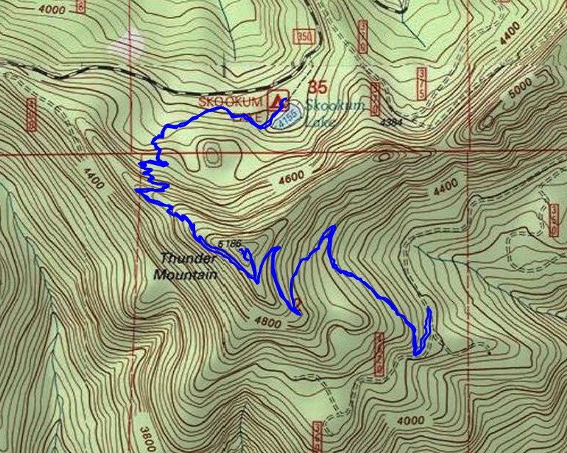
| Location / Trail | Thunder Mountain and Skookum Lake Trails - 542, 543 |
| Weather | Sunny |
| Hiking Buddies | Thor |
| Start / End | 9:45 AM – 1:30 PM |
| Distance / Elev | 6.4 miles 2000 ft elevation |
On the way to the trailhead, I decided to stop at the “dispersed camping area” along road 46 (near the Riverside campground) where Dave had said he saw an insulator which might indicate where the old Cold Springs trail might have crossed the Clackamas River – here is the insulator:

And what looks like it might have been the spot where the trail forded the river (it is hard to see in the photo but it was much more apparent in person):

As we were headed up the 6322 road (I had forgotten how out of the way the trailhead was), we got stopped by this recently downed tree:

Fortunately, I had my chainsaw in the bed so I was able to quickly cut it off the road so we could pass. A little farther up the road, I stopped and got this photo of the mountains visible from 6322:

After some figuring where we needed to go (glad I brought the sheet with the instructions – it is way off the beaten path) we finally got to the trailhead. We suited up and headed out. The trail starts at the end of a short spur road and goes thru an old cut area but soon gets into some beautiful old growth:

A bit farther up the trail you encounter a small spring with a “faucet” next to the trail:

We continued up the switchbacks (which are pretty well graded) – near the top, the trail splits – the Thunder Mountain trail heads up, and the Skookum Lake trail heads down. We opted to go up to the old lookout spot first, since I figured it would be cooler earlier (there is no shade up there).
After taking the spur to the top, here is the final push to the top – it isn’t too far to the old lookout location from the junction:

And part of the view from the top – there isn’t a 360 degree view, but it is a really good view from the old lookout location (Camelsback to the left, Fish Creek mountain right center):

Here is an annotated picture of the Mountains from my peakfinder app of the view a little farther east:

Once on top, I wanted to fly my drone to get some good videos. Unfortunately, I messed up the exposure for part of the flight, so the 360 view was ruined. I did get a circle around the lookout location which looks pretty good.
Drone video from on top of Thunder Mountain:
It was still pretty early, so we decided to head down to the lake and have lunch there. We headed back down the trail and soon got to the junction with the Skookum Lake trail. We headed down this piece. The beginning of this trail burned in 2006, but it is recovering pretty well. I remember seeing how bad it looked after the fire. This is what it looks like now:

The trail heads down the southwest side of Thunder Mountain. At some point it takes a turn north down a series of switchbacks. Somewhere in there I saw this HUGE anthill:

The only place I’ve seen another that large is on the Fish Creek Mountain trail before the fires. That trail used to have several of them that were about the same size. I don’t know what causes anthills to get so big!
A little farther down the trail, we came to this rocky area that had flagging around it after the fires – this was the “safe zone” for firefighters – if things got out of control, they could escape to this area and be safe (the ribbons were removed a number of years ago):

After heading down the hill and a bunch of switchbacks, we finally got to Skookum Lake:

We headed to the north end of the lake where there is an old campsite (you used to be able to drive all the way to that campsite years ago). We stopped, had some lunch and then I flew my drone over the lake for a bit, trying to get a closer look at the old avalanche area, which is quickly becoming hard to spot – it is growing in so much.
Drone video across Skookum Lake:
The other highlight of the day was getting to eat quite a few ripe huckleberries – there were quite a few right on the trail in places and I took advantage of them. They were DELICIOUS!
After doing a quick flight with the drone, I packed it up and we headed back up the trail. We made pretty good time going back up all the swichbacks and soon were back at the truck. We headed home. A good day in the woods!