
| Date | 8/26/2023 |
| Location / Trail | Rho Creek Trail - 569 |
| Weather | Sunny and warm |
| Hiking Buddies | Thor |
| Start / End | 9:30 AM – 2:05 PM |
| Distance / Elev | 8 miles 2000 ft elevation |
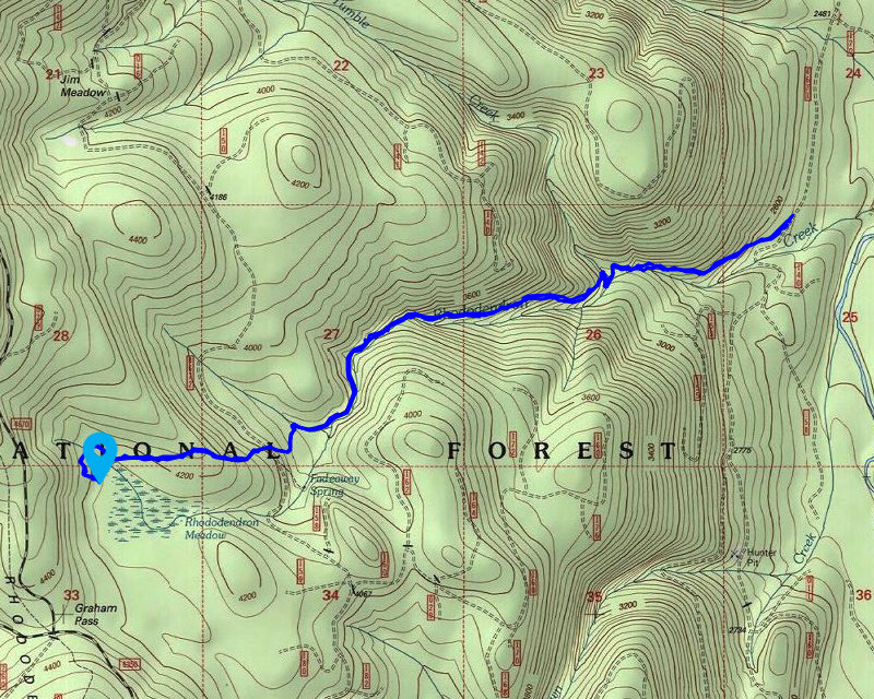
We headed out a bit early and got to the trailhead – the parking is a bit down the road, so we parked, suited up and headed down the road. When I first hiked this trail, over 17 years ago(!), it started in a different spot – the area where it crossed the road had not been found – I’m not sure when it was, but it is nice to hike the “original” tread. It continued across the road and went all the way down to the Clackamas River. I’ve never really looked for tread below the road, but I guess there is some there.
A little bit down the trail, I took this picture of an old blaze, an old cut log and the tread – I just liked it:

A bit further up the trail you get the first good look at Rho Creek – before this you hear it but can’t really see it:

We continued up (this trail is pretty much a continuous uphill climb – but not too steep – just constant) to the Tumble Creek crossing, which looks a lot worse than it is – there is a nice crossing point to rock hop across the creek:

Looking back after crossing the creek:

After crossing the creek, the trail heads south and then does a couple of switchbacks. There was evidence of recent maintenance in here. We got up the switchbacks and came to this last cut log:

Shortly after this log, the trail condition deteriorated a bit. A but brushier, and a few logs over the trail. Not too bad, but you could definitely tell where the recent maintenance had stopped.
We continued up the trail – there are a few pretty brushy spots we had to kind of fight our way thru. I cut a few small logs off the trail. We soon got below the old cut area and went by Fadeaway springs – one of the weirdest springs ever – it is dry in the winter and was full and running ice cold the last week of August:

After letting Thor cool off in Fadeaway springs for a bit, we continued up – soon we got to the 4672 crossing and headed across the road and continued our trip uphill. The beginning is in large timber but soon the size of the timber gets smaller and the trail starts to level out. I had debated on how far to go on the trail and thought the collapsed guard station would be a good place to have lunch and turn around. As I recall the trail beyond the guard station got considerably worse.
We continued along, having to step over a LOT of small trees as we went – there are probably over 100 small trees across this portion of the trail. I had apparently forgotten how far the guard station was above the road. I almost turned back – I was putting a flag on a tree to mark the trail and looked behind it, and there was the guard station remnants:

We stopped, ate lunch and then I flew the drone. Here is the video:
After that, we packed up, flagged the beginning of the continuation beyond the guard station and then headed back. Since the trip back is pretty much all downhill, we made really good time coming back. We got back to the truck a little after 2:00. I figured that would give us plenty of time to head up to Burnt Granite to take a look at things.
We headed up 4670 to where 4650 intersects it and then headed up 4650. You can tell there has been a lot of traffic on the road – the sides of the road were all dusty. We got down almost 4 miles and came to the 020 spur which used to be decommissioned but has now been re-opened to work on this thinning/fuel reduction project (or whatever it is they are doing):

We continued down 4650, looking for the spot where the trail crossed the road, a bit north of the 020 spur. I found it and it has this weird sign propped up next to it:

For one, this isn’t the Rho Ridge trail, for two, I’ve never seen 695 be assigned to Rho Ridge – 595 is Burnt Granite and 564 is Rho Ridge (today). I’m guessing someone found it somewhere and just assumed it was for this trail. At any rate it was kind of cool and kind of weird all at the same time.
I stopped, got out and just verified the lower portion of the trail looked OK. It did, thankfully – all the work they are doing is above the road at this point. We turned around and headed back to the 020 spur. I did something I never thought I’d do on that trail. I actually drove up that old spur road to its junction. I stopped there and got out and looked around. I was able to find the beginning of the trail (which didn’t look like it had been disturbed thankfully):

After checking out the trail, we came back down and went over to look at the project. I’m guessing this is kind of a thinning/fuel reduction project because they are leaving some trees but running a masticator over just about everything else, leaving chopped up branches, etc on the ground:

I looked for the old alignment and was able to find a short segment of original trail:

The rest of it has been obliterated by all this work. I walked to the end of the work area and you can still see the tread heading north out of the work area:

It is intact – for now – I don’t know how far this work area is going to go – I guess we will just have to wait and see. I guess the good news is that once they are done, it will be really easy to build new tread thru there, although it won’t be shaded like the old tread was.
All in all, it was an excellent day – I love the Rho Creek trail and it was interesting to see the work being done near Burnt Granite.