
| Date | 9/4/2023 |
| Location / Trail | Schreiner Peak - 551, 558, 555 |
| Weather | Overcast and foggy |
| Hiking Buddies | Kirk, Ollie and Thor |
| Start / End | 9:45 AM – 7:25 PM |
| Distance / Elev | 14.5 miles 4600 ft elevation |
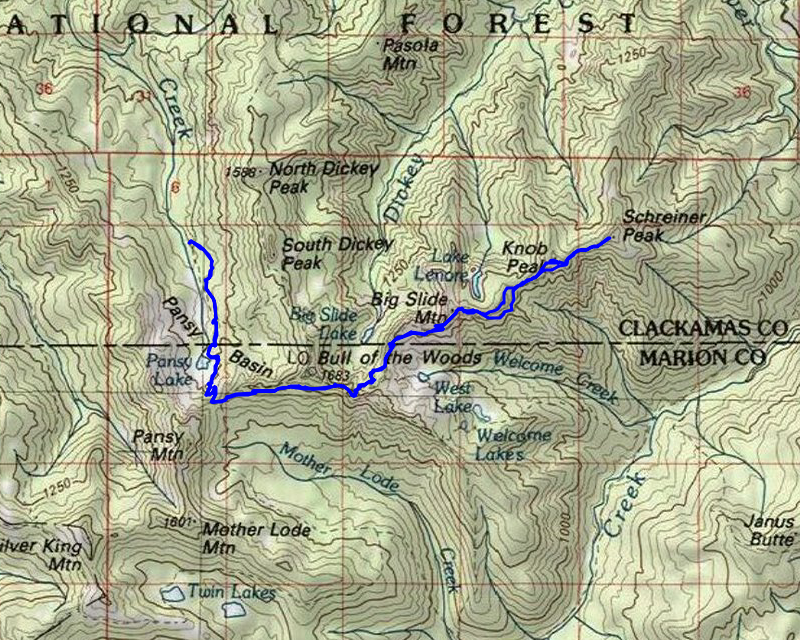
After reviewing possible routes (we looked at coming in from the Bull of the Woods trail, Elk Lake Creek trail and the Pansy Lake trail), we decided on the Pansy lake trail option. It was the shortest of the 3 options and only slightly more elevation than the Bull of the Woods option. My estimate put it at about 13 miles round trip with about 3300 feet of elevation. I knew it was probably going to be more than that, and I was right.
Since we knew it was going to be a long day and the days are getting shorter, we decided to get an earlier start. We left the house a bit after 8:00 and made it to the trailhead about 9:30 or so. We found two cars at the trailhead, which kind of surprised me. We got suited up, leashed up the dogs and headed up the trail. Not too far up the trail it crosses a small creek, which I think is the outlet from the Dicky Lake basin – it is kind of pretty:

A bit farther up the trail enters part of the burned area – this was from the 2021 Bull Complex fire:

The fire damaged area didn’t last too long and we were back in unburned forest. We knew it was going to be a long day, so we didn’t too much “extra”. We soon got to Pansy Lake and decided not to go check out the campsites – we continued up the hill and soon came to the obligatory viewpoint of Pansy Lake and the Pansy Lake basin:

A little farther up the trail we neared the junction with the Motherlode trail – just as we were approaching we got back into the burn area:

We stopped here for a quick drink and then continued on. At this point, we were about 2 miles in and it seemed like we were making good time. We headed east on the Motherlode trail which was burned pretty heavily at the beginning:

A little farther up the trail the burn got even more intense – there is really nothing left in this area now:

The good news is that they have done quite a bit of maintenance in this area, including a bunch of tread work, so hiking this part was pretty easy.
A little farther up the trail, I was surprised to encounter an unburned area:

I think we went thru 2, maybe 3 small unburned areas, but most of this segment of the Motherlode trail was burned at least to some degree. The good news is that hiking this segment was pretty easy due to all the post fire maintenance that has been done.
It wasn’t too long before we got to the junction with the Welcome Lakes trail. The trails in this area always confuse me, but I believe it is the Welcome Lakes trail that heads up to Bull of the Woods and the old lookout (which burned in the fires). The segment that heads up to the lookout appeared to have some maintenance done, but we were heading east, and that segment had not had any work done to it. We encountered a lot of stuff like this (and worse):

Fortunately, we didn’t have to hike this trail too far. We got to the point where the Schreiner Peak trail joined it, which also was unburned:

Our fortune didn’t last too long, however as the trail soon turned to this:

The trail goes downhill pretty steeply, and has a number of switchbacks on it. Some of it was not too bad, and some parts were difficult to navigate. Portions of tread had been burned out as well as quite a few large logs were down on the trail.
We finally got down thru all the switchbacks and came to a small pond:

I knew the trail went around this somewhere but we couldn’t see the trail at all (more on that later), so we just walked the edge of the pond. At some point we found the trail on the far side of the pond. At this point, the trail was in reasonably good condition and there wasn’t too much blowdown on it. This is what it looked like in this flat area:

We made it thru this flat area, passing the junction with the West Lake way trail. Shortly after that, it starts heading up. When we got to a switchback with a good view, we decided to stop for lunch. I think it was about 12:15 or so. I thought we were doing pretty well since we had only been hiking a little over 2 hours and we were already 2/3rds of the way to our destination. What I didn’t really consider was the last third was going to be a LOT more difficult than the first two thirds.
We stopped for a pretty quick lunch, but given there was really no sun and a bit of a breeze it was kind of chilly. We ate pretty quickly and then continued up the hill. At some point on the way up, we encountered another small unburned area:

And along the way, we got good views of West Lake (which also didn’t burn) and both of the Welcome Lakes:

We worked out way up the trail and soon got to the junction that headed down to Lake Lenore. This is where the official trail ends and where the trip got quite a bit harder.
We started on what looked like it might have been the old trail but that quickly disappeared. We walked up to the ridge above Lake Lenore and I got a good picture of what it looks like now:

Compare that to what it looked like back in 2006, the first time I was here and before all the fires:

We continued along the ridge and over “Not Knob Peak” (we mistakenly thought the first peak was Knob Peak – it was behind it). We passed it, and soon realized our mistake. This was the view of the REAL Knob Peak from “Not Knob Peak”:

Once we rounded Knob Peak, we finally had our objective in sight – we had been hoping the fog would clear all day – we were fortunate for the views we did get:

We made our way across the ridge to Schreiner and made the last final push to the top. We made it to the top just about 3:00 – just over 5 hours from when we began.
It was interesting on one spot just below the summit there was evidence of an old campsite – fire ring and what looked like a wind shelter:

And the most interesting thing was this big rock pile monument at the summit:

We took some photos, I did a very quick drone flight, even though the views weren’t great.
Drone video from the top:
This was the view looking over to Pasola and the big Slide above Dickey Creek and the Collowash:

We didn’t spend too much time on top since we knew we would be kind of racing the clock to get back to the truck before sunset. It was already after 3:00 – if it took us as long to get out as it did to get here, we’d be at the truck after 8:00 and sunset was 7:42, so it would be dark by then. We were hoping the trip down would be faster than the trip up.
We headed down and came back a slightly different way. Kirk wanted to summit Knob Peak too, so we did that. This was what the top of Knob Peak looked like:

We then tried to follow the ridge, although that became very difficult due to a sheer rock outcropping. We ended up doing kind of a sketchy down climb to get back down to the ridge proper. After that challenge, we ended up finding what certainly looked like old tread and followed it as far as we could. In looking at the old maps that show the trail, I’m pretty sure we did find the old tread in that spot. It did disappear but we were able to follow it for a while.
It felt really good to get back to the junction down to Lake Lenore. We stopped here briefly to rest a bit and also to hydrate. We didn’t spend too long since we were racing the clock.
On the way down, I noticed this cool rock formation that was near West Lake – I hadn’t noticed it on the way up:

We continued down the trail – for the most part, this segment of he trail was in pretty decent shape – a few logs and a few weird areas of brush, but overall not too bad. We soon made it down to the flat area and we followed to the trail – and this is why we missed this cutoff on the way up – there were probably 25 trees down in a 50′ section of the trail:

After getting thru that, we had our last uphill of the day, fighting our way up all the switchbacks to the ridge above Big Slide Lake. After all the effort of the day, it was tough getting back up those switchbacks, but once we did, we were basically on a downhill journey to the truck. We were making really good time. I was hoping we might be able to make the truck by 7:30 and we did end up beating that by a few minutes. I think we got to the truck at like 7:23. The dogs were both exhausted and jumped right into the truck. We quickly packed up and headed out.
By the time we got back to Estacada, it was about 8:45 – we stopped at Time Travelers and they were technically still open but it was too late for food, so we ended up going over to the River Mill Saloon and had a burger and a beer. It was a really good way to end a pretty amazing day of exploration. Schreiner Peak is a very interesting peak – If it weren’t so difficult to get there, I’d do it again – but due to the difficulty, I doubt I will be going back there. The only thing that could have made the day better was better visibility. I’m just glad I was able to rise to the challenge of climbing Clackamas County’s highest unshared peak.