
| Date | 9/10-9/14/2023 |
| Location / Trail | Necklace Valley - Alpine Lakes Wilderness |
| Weather | Varied from Overcast to Sunny to light rain |
| Hiking Buddies | Carly and Otis |
| Distance / Elev | 31.2 miles 8650 ft elevation |
- 2002-Duffy Lake – Mt Jefferson Wilderness
- 2004-Red Lake
- 2005-Shining Lake
- 2006-Big Slide Lake – Bull of the Woods Wilderness
- 2007-Doris and Cliff Lake – Mink Lakes Basin
- 2008-Twin and Silver King Lakes – Bull of the Woods Wilderness
- 2009-Elk Lake Creek, Welcome Lakes – Bull of the Woods Wilderness
- 2010-Bagby, Whetstone, Battle Ax Creek – Bull of the Woods Wilderness
- 2012-Eagle Cap – Lostine/Minam Rivers
- 2013-Goat Rocks
- 2014-Enchantments
- 2015-Indian Heaven
- 2015-Devils Dome
- 2016-Thornton Lakes
- 2017-Sawtooths
- 2018-Eagle Cap- Eagle Cap – Lakes Basin
- 2019-Three Sisters Loop
- 2021-Olympics Coast Trail
- 2022-Alpine Lakes Wilderness
- 2023-Alpine Lakes Wilderness – Necklace Valley
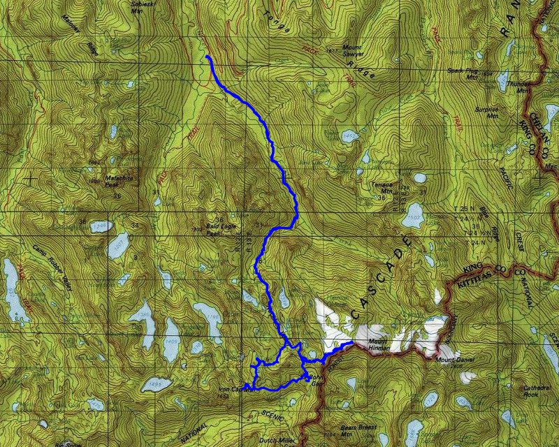
The destination for this trip was in the same area we went last year, just one drainage to the west. We had a hard time coming to agreement on a plan for the trip, but this is what we finally came up with, a “lollipop” loop (which worked pretty well):
- Day 1 – Trailhead to La Bohn Lakes – 9.1 miles and 4600′ of elevation
- Day 2 – Do a day trip up to Hinman mountain and then move camp to Chain Lakes – 5.5 miles and 2000′ of elevation
- Day 3 – Cross country trek to Tank Lakes and then an optional day trip up to Otter Point – 4.5 miles and 900′ of elevation
- Day 4 – Tank Lakes back to the trailhead – 11 miles and 400′ of elevation
Total Planned: 30.1 miles and 7900′ of elevation
Actual: 31.2 miles and 8650′ of elevation
Day 1 – Trailhead to La Bohn Lakes
The first day was going to be the toughest. Not only was there a fair amount of mileage but also significant elevation gain. The first 5 miles were expected to be pretty easy, just following the east fork of the Foss river. As soon as you cross the river, you start a pretty aggressive ascent. The trail is pretty good, but it gains about 2800′ of elevation in about 2.5 miles. It is a pretty relentless ascent that gets pretty steep in places. I wanted to make sure we got an early start so we weren’t trying to race the sun, so we wanted to get to the trailhead by 9am. We were a little bit late, but it was OK in the end. We planned conservatively and things worked out well.
We got to the trailhead and it was full which wasn’t a surprise. We had to park on the road. One thing that was a surprise – it required a NW Forest pass and they didn’t offer the option of buying one at the trailhead. I didn’t have one, and Carly’s was expired. We figured we would probably get tickets but that was OK – we figured it was just part of the cost of the trip (more on that later). We were also a bit concerned when we saw broken glass at the trailhead parking lot. Apparently there had been some break ins in the past. We were not going to let that ruin the trip for us, so we suited up, filled out our wilderness permit and headed down the trail:

We didn’t really realize it on the way in, but the first part of the trail appears to be a very, very old road. On the way out, we realized the road went quite a ways – the spots where the trail isn’t flat appears to be caused by washouts over the years.
It wasn’t too long before the trail went above the road (not sure why) and went to a crossing of Burn creek on this nice bridge:

After crossing the creek the trail heads back down to the old road and continues along the river for quite a ways – at some point the road ended, and it turns into a “real” trail. The portions along the river were really pretty:

There were also quite a few very large trees along the river:

A ways down the trail, we came to a nice campsite right along the river that had a bunch of pieces of old mining equipment:

We made really, really good time on this segment of the trail – mostly because it was good trail and it was pretty flat. I think we did the first five miles in about 2 hours. Not a bad pace with a full pack on your back. At that point we crossed the river on this bridge:

We stopped here to rest before our big ascent – this is where the day got hard. While we were there, a couple had a dog who was unleashed and they seemed oblivious to us (Otis was with us). They finally leashed their dog and we were able to cross the creek.
We rested for a bit, had a bit of food, and then started our ascent. It goes thru the trees, next to another campsite and then into a rock field for a bit before re-entering the woods – all the while going up. Sometimes not too steeply, sometimes VERY steeply – the common theme was UP.
As we were going up, we encountered quite a few people who were coming down. We started this trip on a Sunday, so people were coming back from a weekend in the wilderness.
A mile or so up the trail, we came to a plaque in a rock and a footbridge which was kind of interesting:


A little past the bridge the trail got VERY steep, although they had built rudimentary steps into the trail which made it a little easier:

After struggling with the elevation gain, we finally topped out into the Necklace valley and Jade lake, where we had lunch on the south end:

After a nice lunch, and re-filling our water supplies, we continued on. For a bit, the going got easier, as the trail was mostly flat in the Necklace valley. A lot of the trail looked like this, with lots of huckleberries flanking the trail:

We soon got to the cabin at Emerald Lake which was kind of interesting, although it has seen better days – on the way back after the rain on Tuesday night, it did seem mostly dry inside though:


And a distant shot of Emerald Lake (we didn’t take time to go over and look at it much):

A little farther up the trail, we finally got our first glimpse of where we would (hopefully) be spending the night – up in the La Bohn lakes basin, which was another 1000+ feet above us still. When I look at the hill, I couldn’t see how we were going to get up there:

At the end of the valley, we headed over to a “lake” and then started up the big rocky hillside. Along the way, Otis found a bit of snow he could play in:

We continued up the rocky slope – it was pretty steep, but since you can’t go too fast, it isn’t as hard as what we did to get up to Jade lake I didn’t think. Here is us part way up the rock field:

At some point, we kind of headed over into the trees and continued up:

And at some point things kind of leveled out somewhat and we had a real trail again:

A little farther we finally came to the first La Bohn lake:

We hiked around a bit, looking for a good campsite. We finally found one at one of the smaller lakes:

This was our lake from the other side:

And this was the biggest lake, which was just over a small hill from us:

Unfortunately, once we stopped, the bugs found us. They weren’t mosquitoes, but small gnats of some kind. I was surprised there were any bugs at that elevation and this time of year. When the breeze picked up it was OK but it wasn’t too breezy. They seemed to like me more than Carly though.
We got to our campsite about 5:00, an hour earlier than we had planned (which was good – sunset was about 7:30 and it takes a while to setup and make dinner and clean up). After setting up camp, we cooked dinner and cleaned up. Since the bugs were annoying, we were tired from the day and the sun was going to go down soon anyway, we just went to bed.
Day 2 – Summit Hinman Mountain and then move camp to Chain Lakes
The plan for today was to get up, eat breakfast and then summit Hinman. After that we would come back down, break camp and move it down to the Chain lakes basin.
Things mostly went to plan for the day. We got up mostly with the sun, made breakfast and then started our ascent of Hinman. The route up was similar to the one we took the day before – up a rock field, kind of zigzagging our way up the hill to avoid cliff bands.
We had to find the “trail”, which we soon did, and we mostly followed it up. As we were starting our ascent, I took this photo of our lake and its bowl:

As we continued up the mountain, it got a bit rockier and we had to adjust our route:

As we got higher, we started to be able to see the glaciers on Hinman. Below them were a few small lakes:

And here was our first good look at one of the glaciers – at this time of year they were mostly ice, so we tried to avoid them:

We negotiated our way around the first glacier and we thought we had our destination in sight, but we got fooled a bit:

We had a bit farther to go – and more glaciers:

After negotiating the second glacier, we finally saw the top in sight:

The problem was that we had to get across the glacier – we tried going on the rocks above the glacier but they were extremely unstable so we walked right on the top edge of the glacier, right next to the rocks. That worked reasonably well and we made it across, ready for the final push to the top. It got steep, but we finally made it to the top.
I took a bunch of photos from the top – this is Glacier Peak:

And a lake that many maps don’t label – but it is called Pea Soup lake (not sure why) – it has a cool waterfall below it on the outlet:

Here is Hinman’s “neighbor”, Mt Daniel, which Carly and Kirk climbed last year:

And I had to get a picture of Otis on top of Hinman – he was a trooper getting up there:

Mt Ranier is such a huge mountain – it is easy to spot on the horizon:

We spent a few minutes up there enjoying the view, eating a bit and resting. It was actually pretty pleasant up there – not terribly windy.
After a bit, we decided to head back down. We came to the first glacier – the one we had problems with on the way over. We tried a different tactic this time – Carly brought micro spikes so she put them on – I tried walking on some “breakpoints” (not sure what else to call them) in the glacier – it gave me a foot hold so I didn’t slide down the glacier. This was Carly starting out traversing the glacier:

The micro spikes worked great for Carly, and I went slowly and carefully and I didn’t have any issues getting across the glacier. After we had gotten thru the glacier and we were heading down, we encountered another group coming up. They had a dog so we had to handle that. They asked how it was and how the glaciers were. Apparently they had been told you didn’t need to bring any equipment (micro spike or crampons would have been useful). We told them what we had done and then wished them luck. We continued down the hill. We tried to go back the same way we came (mostly) but we missed a few spots – we did finally get back down to camp. I think it was only about 4.5 miles or so round trip but it took us about 5 hours to do it.
When we got back to camp, Carly fed Otis – he ate most of it, but then just pretty much passed out – he was a tired doggie:

We rested a bit, ate a bit more and then broke down camp and headed the short distance down to the Chain lakes basin:

While the maps showed “prospecting”, Neither of us were expecting to see a lot of artifacts or evidence of mining. Boy, were we wrong! There is a LOT of stuff to see in that basin and a lot of activity has gone on there over the years. I’m still trying to find more information on the mining activities there but it looks like it started in 1898 – some say it was done by 1907 but it seems like it might have had activity after that.
Anyway, we were looking around for a campsite, but found some of the artifacts pretty easily. This is a huge shaft at the top of the main/largest mine:

We wandered around a bit – I still don’t know exactly how many lakes there are in this basin – the map shows 8 and that might be correct – but you can’t see all of them at the same time – they are all in different elevations and there are the big granite “slabs” between many of them as well. Here is one of the chain lakes:

And another:

We soon found what we thought was a good campsite – it had a nice view and was close to one of the larger lakes:

Carly had been told that there was a cabin on the south side of the basin. I think the cabin is long gone, but I’m sure it was up on the hill to the south:

We walked around the area just exploring. Between two of the lakes there was this little waterfall which was kind of neat:

Another thing that we notices was that most of the lakes looked to be rust stained – we were guessing from the mining activity – but something about that seems to stimulate the moss – we saw a bunch of REALLY thick moss around those lakes:

And the whole basin is covered with the big granite slabs:

We walked over to the south side up on the hill where it looked like the cabin would have been. I’m pretty sure this spot was where the cabin used to be:

And there was another flat spot where some other building might have been years ago:

Near this flat spot someone had laid out a bunch of artifacts that had been found – it was kind of interesting to see all of them in one spot:

From the top of a rock near here, we found a benchmark and got a really nice view south:

After exploring the old cabin site a bit, we continued wandering around. On the way in, Carly had seen something at one of the lower lakes. We didn’t look at it then, but we made our way back up there and found it was some kind of pipe/valve near the upper lake – I wonder if they used it for water for mining and/or the cabin?:

On the west side of the basin there is a very short mine on the shore of one of the smaller lakes – I read that this was short because nothing was found in it:

We wandered towards the middle of the basin where the main mine/shaft is and saw a big pile of old timbers – I assume these were to support the mine shafts:

And a big pile of old rusty track rails:

I think this is some sort of old winch:

This is a picture of the main mine shaft – you can tell this area had a LOT more activity around it:

There were tailings from main mine all over the place – they went all the way down into the lake:

This is where we chose to put our campsite for the night – just above one of the larger lakes:

We had a really nice view south from our campsite:

We spent a lot longer looking around than either of us thought. There is a lot to see in the basin, and the basin itself is pretty large.
After we got done exploring, we made dinner and cleaned up. I was really happy that there were no bugs here like there were at La Bohn.
Sometime during the evening, the fog started moving in:

It made it get dark a bit earlier. As with the prior day, we pretty much went to bed with the sun. Another awesome day of adventures!
Day 3 – Cross country trek to Tank Lakes and then an optional day trip up to Otter Point
On Tuesday (day 3), Carly decided to sleep in a bit. I got up, made breakfast, cleaned up and she was still sleeping, so I spent some time just enjoying being in such a beautiful place. I wandered around the basin a bit and found some things I hadn’t seen before, or things I had seen, but forgot to get pictures.
First, on the way in, I saw a bunch of these “holes” in the granite slabs. They look exactly like a tree would have been there:

My theory is that there was a tree and the magma that formed these slabs flowed around the trees and they ended up burning out, leaving the depressions.
I also go a picture of the upper shaft, which we saw on the way in the day before – this is kind of scary as it would be really easy to fall in and it would be a LONG drop so we made sure to keep our distance:

Up on top there was some other old structure – I’m guessing maybe it was an equipment shed or something – it seemed to be pretty much square – maybe 30′ square:

When I got back to camp, Carly had gotten up and Otis was looking to the south and appearing to contemplate life – I just thought it was a funny picture:

After Carly ate breakfast, we broke camp and headed due west – our cross country route to Tank Lakes. Once we crested the hill, this is the view we had of the route we had to traverse – which was more difficult than I had been imagining:

We headed down the steep hill, working our way down to the flatter area. Once we had gotten down to the flatter area, I took a picture of the hill we had just come down:

The plan was to make our way down that initial hill, then across a rock field to a shelf and proceed on the shelf across the side of the hill. It turned out to be a pretty good plan, although it was WAY harder than I thought it would be. Here is us partway on the “shelf”:

A little bit farther I took this shot showing how far we had come thru the valley:

As we were progressing over the “shelf” we got a good look at Williams lake below – I found out there is a mine there as well:

This was one of the large rock fields we negotiated:

After a long traverse on large boulders, we finally made it to the “slabs” section:

The slabs continued for a while and there was a reasonable trail thru most of it, with intermittent cairns to help guide us. We continued on thru the slabs:

It was around this time that we started feeling a bit of drizzle. It wasn’t much, just a few spits here and there, but it was definitely raining. I put on my raincoat – I was already on the verge of being too cold anyway, so my raincoat was perfect.
A bit farther up we saw a trail taking off up thru a cut in the rocks. It appeared that might be a “shortcut” to Tank lakes – we assumed the “real” way to Tank lakes was around the corner so we continued on the trail. We wandered around a bit and took a wrong turn – we realized we were not going the right way pretty quickly so we turned around:

At this point it was after noon already so we decided to stop for lunch. Originally we were hoping to eat lunch at Tank Lakes but it took us much longer than we thought. This was our view at lunch, looking down on Bonnie lake:

After eating lunch, we turned around and went back to the trail we should have taken on the way in (the one we thought was some sort of shortcut):

This trail gained a bit of elevation and soon put us on the approach to the Tank Lakes basin:

And soon we saw the first tank lake:

To the west was the rest of the main Tank Lakes basin:

We looked around at campsites and tried to figure out where the trail continued – we took another wrong turn around the island at the north end of the lake and turned around and kept going up to find the second lake. On the way, we got a really good view of where we were on Sunday – up in the La Bohn lakes basin:

After some searching (which seemed like it took forever), we finally found the second tank lake, long and narrow, down in a bit of a hole:

We decided to skip camping at that lake and go back to the larger lake. On the way back, we heard a Marmot do its “whistle”. Carly noticed him sunning himself up on a rock. I took a zoomed in photo (which is why it is blurry) – he did his whistle two or three times at least:

We headed back to the main Tank lake and Carly had noticed a nice campsite right next to the trail on the way in. Since we hadn’t seen anyone else, it seemed like a good spot.
This was our campsite at tank lake – if it were clear it had an incredible view of Summit Chief Mountain:

We setup camp and Otis laid in the tent to rest. We left the fly off the tent as usual and most of our stuff was outside. It was very foggy and Carly said if it started to rain, we’d put the fly on. It wasn’t too long before it started to drizzle more. We put the fly on and it got a bit harder so we kind of threw all our stuff in the tent and got in. It started raining reasonably well – we kind of took a nap for a while in the tent. While we were in a couple came in from the north and setup their tent on the opposite site of the lake. It continued raining most of the afternoon and into the evening – there were a few breaks but it was more rain (drizzle) than not. We heated our water outside the vestibule and ate dinner inside the tent. It was kind of a weird way to do dinner. Since it was so foggy, it got dark early so we just went to bed, hoping the rain would stop overnight.
Day 4 – Tank Lakes back to the trailhead
We woke up on Day 4 (Wednesday) to no rain. It was still a little cloudy in spots but the tent had dried out a little bit. Since we had a long hike ahead of us (and I had a long drive after that), we wanted to get an early start. We woke up about 6, and quickly had breakfast and packed up camp. I think we started hiking about 7:30. We said goodbye to Tank lake on our way out:

We went north a short way and then headed east down a wash – we needed to get back down to Necklace valley and on the “real” trail. This was our route down the wash:

Along the way, we got a good look at La Bohn basin:

And I overlaid our rough route we took up the side of that hill – I am still amazed we did that with full packs on:

We successfully negotiated all the boulders and soon made our way back down to the Necklace Valley floor. We easily picked up the trail we had come in on and headed north. We made pretty good time thru here. Coming down that wash was quite a bit slower due to all the rocks, but now that we were on an easily to follow trail, we were making good time. As we headed north, it got increasingly foggy. When we approached Jade lake (where we had lunch on Sunday), it was quite foggy:

From Jade Lake, we did the long downhill, which was easier than it was coming up, but still relatively hard – going downhill, especially steep downhill, is hard on the knees. We soon made it to the East Fork Foss river crossing. We stopped there to refill our water and have a snack before continuing on the relatively flat final 5 miles of our day.
This last portion went pretty quick, just like it had been on the way in. We made it back to our vehicles just before 1:00 – just in time for a late lunch in Skykomish! We got back to our vehicles and found to our surprise and delight that we didn’t get any tickets and had all our windows intact (no break ins) – win/win!
After somewhat cleaning up and changing clothes, we headed into Skykomish to get a late lunch before going our separate ways. Carly would head east back to Wenatchee and I would head west to Seattle and then home. We had a great lunch at a bar in Skykomish – Homemade chicken sandwiches! We had some great conversations and discussions about the trip but since I had a long drive ahead of me, we cut it short. We both headed home about 2:30.
Another incredible trip – It will be interesting to see what trip #21 will be next year (hopefully we are able to do one).